 Did you know they can be ordered ON-Line??
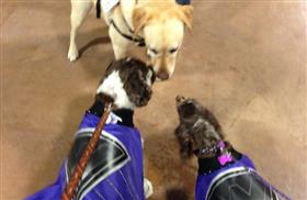
Check out some of the Dogs of Best Friends Dog Park in the 2014 Friends of Winnebago County Dog Parks Calendar! The Calendar is also loaded with Dog and Human Holidays! Need a calendar or two shipped? Click here
*Don’t forget take & save your high resolution photos of your dog at Best Friends Dog Park or the Friends of Winnebago Dog Parks, Inc. events for the 2015 calendar! Make your pup a STAR!!
Category: odds and ends
U.S. Monument Honoring War Dogs To Be Dedicated
 SAN ANTONIO (AP) — The first national monument honoring the war dogs that have fought and died with U.S. troops while also bringing them comfort is to be dedicated in San Antonio.
The U.S. Working Dog Teams National Monument will be dedicated a week from Monday at Lackland Air Force Base. That’s where many of the U.S. military dogs are trained, as well as treated when wounded.
The dedication marks the end of a tour that began in January at the Tournament of Roses in Pasadena, Calif.
The driving force behind the monument is John Burnam, a 65-year-old veteran military dog handler who designed the monument. The monument depicts the modern military handler and four dogs — a Doberman, German shepherd, Labrador retriever and Belgian Malinois, all breeds used in wars.
Originally posted on the Huffington Post website at: http://www.huffingtonpost.com/2013/10/21/us-monument-war-dogs_n_4136213.html


Dog Halloween Safety
 Halloween is filled with frights, but you can leave the spooks to the ghosts this holiday by keeping your dog out of harms way.
Posted: Oct 16, 2013, 10 a.m. EST on www.dogchannel.com
Check out these common Halloween hazards and tips to have a fun and safe holiday for the whole family.
Halloween Candy
Everyone loves candy and on Halloween candy is everywhere. While your dog may have never been tempted by sweet treats before, keep in mind that candy probably has never been so accessible! On Halloween candy can be found in bowls, on tables, next to doors, in trick or treat bags being carried at dog level and in the hands of small children who might think your dog would like to share the snack. Candy also makes it onto the floor when spilled during the handout or dumped out for the all-important candy sort. Continue reading “Dog Halloween Safety”
How to Act in Public with Your Dog
 It’s the holidays, pet expo season, and fall travel season all rolled into one: That’s the good news.
There are pet parents who will engage in one or all of the above with a less-than-well-behaved dog and less than customary human manners: That’s the bad news. Continue reading “How to Act in Public with Your Dog”
10 Things Dogs Have Always Wondered about Humans
From our friends at ![]()
#1 – Why do you think we need more fur? 

The WIOUWASH – YES you can take your dog ON LEASH
The Winnebago County Portion of the WIOUWASH
The flat base is very good for walkers, hikers, bikers, horseback riders (summer) and snowmobilers. The Winnebago county portion of the trail runs from Oshkosh north through Winnebago and Outagamie counties and halts in Hortonville. This section has 21.8 miles of abandoned railroad corridor.
Please keep in mind the map is not to scale. Many different forms of recreation are pursued on the trail, so please be courteous and give everyone the space they need. We hope that you enjoy the time you spend on the recreation trail.
Brief Overview
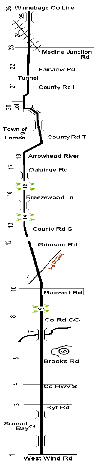 The main parking lot for the trail is located off Westwind Road. The inset map shows the location of Westwind Road in relation to Highway 41 and 45. The distance to Ryf Road is 1.3 mi. Restricted to dogs on leash area.
- Sunset Bay parallels the trail in this area. This is an excellent spot for shoreline fishing as northern pike, white bass, perch and crappies can be caught here. Spring and Fall provide opportunities for waterfowl and bird watching. Restricted to dogs on leash area.
- Ryf Road. The distance to County Highway S/County Road Y is 0.6 mi.
- County Highway S/County Road Y. One of our main lots is located at this intersection for your parking convenience. Caution! Crossing this stretch of highway can be difficult please use extreme caution. Distance to Brooks Road is 1.1 mi.
- Brooks Road. Look for birds that prefer dense, brushy habitat along this section of trail. Distance to “GG” is 1.1 mi.
- Caution! Be sure to stay on the trail in this area as there is a private gravel quarry off the east side of the trail.
- This high trestle railroad bridge is the only one of its type on the trail. It spans Daggett Creek.
- County Road GG. A mini-lot (Max. 4 vehicles) is located on the south side of this road. Distance to Maxwell Road is 0.5 mi.
- Running 1/3 mile north of County GG is the first of three native tallgrass preserves. Spring and mid-summer wildflowers of many varieties abound in this area. This is a great place to look for birds that prefer an open field environment.
- Maxwell Road. Distance to Hilltop Road is 0.4 mi.
- Hilltop Road. Distance to Grimson Road is 0.1 mi.
- Grimson Road. Distance to County Road G is 0.5 mi.
- County Road G. The second main parking lot along the trail is located in Allenville off County Road G. Distance to Breezewood Lane is 1.5 mi.
- The second native tallgrass preserve is located about 1/3 mile north of Allenville and runs for approximately 1/3 mile ending just before the cut made through the hill.
- Breezewood Lane. A mini-lot (Max. 4 vehicles) is located on the north side of this road. Distance to Oakridge Road is 1.0 mi.
- The third native tallgrass prairie area is located about ½ mile south of Oakridge Road and is about ¼ mile long.
- Oakridge Road. A mini-lot (Max. 4 vehicles) is located on the north side of this road. Distance to County Trunk T and Larsen is 1.6 mi.
- Where the trail intersects the Arrowhead River, we leave the old railroad bed and bypass the community of Larsen by following along the east bank of the Arrowhead River (Larsen Drainage Ditch). We will rejoin the original railroad bed north of Larsen.
- County Road T. Distance to County Road II is 0.7 mi. If you follow County Road T to the west you will enter the community of Larsen.
- A parking lot for trail users is located behind the Town of Clayton Town Hall. If you use this lot be sure to go north when you leave the lot. The trail to the south of the parking lot entrance is privately owned and trespassing is prohibited.
- County Road II. Approximately ¾ mi. a tunnel allows passage under Hwy 10. Distance to Fairview Road is ¼ mi.
- Fairview Road. As you travel the trail section between Fairview Road and Medina Junction Road to the north watch for deer in the adjoining farm fields, particularly during late summer and fall. Distance to Medina Junction Road is 1.3 mi.
- Medina Junction Road. A mini-lot (Max. 4 vehicles) is located on the south side of this road. As you travel north on the trail from this point you will be in the State of Wisconsin Rat River Wildlife Area. The area off the trail is a small part of this 10,000+ acre wildlife area. Distance to the Winnebago/ Outagamie County Line is 0.9 mi.
- Caution! Use caution when crossing the railroad tracks as the trains travel through this area at a high rate of speed.
- Rat River Bridge. As you move through this section of the trail look for beaver, muskrats, deer and many varieties of water fowl and song birds. Keep your eyes open for potholes in the trail caused by various “critters” burrowing into the trail bed.
- Winnebago/Outagamie County Line. If you desire to travel further the trail continues into Outagamie County for approximately 6 more miles ending just south of Hortonville, WI.
Additional Note
There is a separate section north of Hortonville. It runs 24 miles from Split Rock to Birnamwood. The WIOUWASH Trail, which will ultimately extend from Oshkosh northward through Langlade County, enters Shawano County near Split Rock and passes through the villages of Tigerton, Wittenberg, Eland, and Birnamwood near the county’s western border. Several gaps remain before a continuous trail is in place (including the segment from Birnamwood north through Aniwa to the Langlade County line). Ongoing efforts are being made to acquire right-of-way or obtain the necessary easements to complete the trail. Once completed, the Shawano County portion of the WIOUWASH Trail will be approximately 30 miles in length. – Source: Waupaca County Website.
You can find this information on the Winnebago Parks website, click here to go to it
To print out a copy of this page as a PDF , WIOUWASHTrail
Times have changes by Forrest Run Pet Cemetery & Cremation Services
Check out how things have changed from our friends at Forrest Run Pet Cemetery & Cremation Service.
It’s safe to say that times have changed for pets and the way we care for them since the debut of the movie Old Yeller. For those that don’t know, “Old Yeller” was the story of the life of a remarkable Yellow dog that wandered into the life of a family who lived on a ranch back in the days of the old west. The movie was made in 1957, but was set in the late 1860’s. The part that made the movie famous was also the worst part and the most difficult to watch. Read more by going to their blog click here
Construction & Grand Opening of the Tribal Heritage Crossing
YES you can walk with your dog ON LEASH on the WIOUWASH State Recreational Trail! Click the PHOTOS to see more photos of what you may see on the bridge as well as some construction photos and the grand opening.
Watch for more information on the Wiouwash Trail this week.